Saline River Valley Landmarks
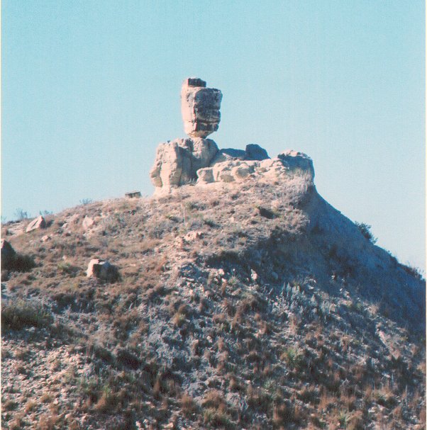
Balance Rock (located 1-11-18 in the hills behind Jennings Home) Located approximately two miles north on an oil lease road. You would have found a large rock balancing on a point of another rock, there were several rocks that balanced, but sometime in the 1970’s a portion toppled off. Now (2009) it no longer exist, so I'm glad I took the pictures when I did.

King Hill (Codell Ave runs north up King Hill into Rooks Co, KS) NE/4 3-12-17 & SE/4 2-12-17
King Hill was named for the family that lived at the bottom of the hill (Not part of Rev. King’s family)
The hill was higher, but the county has knocked the humps down a bit and have also hauled rock from here to put on the local county roads. Paper Moon was this scene when Ryan & Tatum O’Neil were in the old truck at the end of the movie. The elevation of King Hill is 2077.
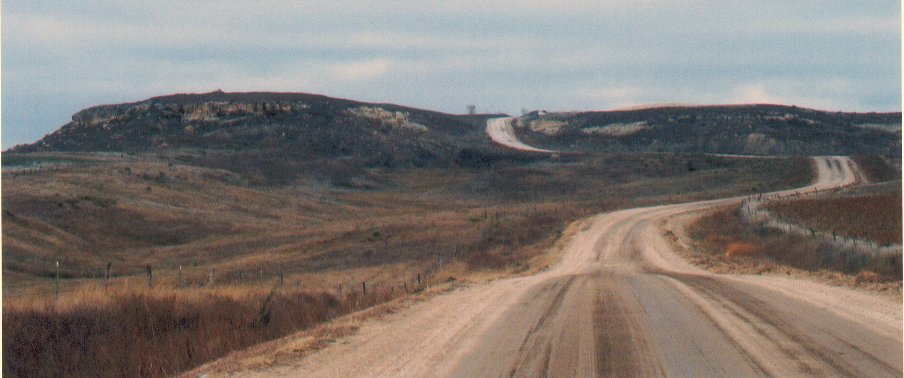
Devils Card Table (located in NE/4 NW/4 of 1-12-17, can be seen driving north on 335 th Avenue to the Rooks Co. line, located on the west side of the road, a free standing hill, that is flat on top, elevation of 2077.

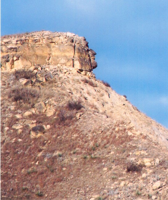
Indian Head Rock (located on the Hadley Range, 20-11-17) From the intersection of Saline River Rd & Hadley Range Ave, travel south into the hills on a gravel road approximately 1 ¼ miles, you will see the hill to your right (west), turn onto an oil lease road, following it till you arrive on the backside of the hill. Looking to the northeast you will see the profile on the Indian brave in full headdress.
Brumitt Cave (Private property) located in Brumitt Canyon
Kaba Canyon – The road is now labeled on maps as Toulon Ave. It starts at the Intersection of the Saline River Road & Toulon Ave, and runs north into Rooks County, Kansas. Upper Turkville School was located ½ mile north on the east side of this road in 8-11-17 before being located where it stands today. It was named after the family that lived there.
7th Calvary Cave (Destroyed in 1993 Flood) located west of Hwy 183 along the Saline River (There is suppose to be an article in the Hays Daily, I need to look up)
Fire Cave located west of Hwy 183 along the Saline River (still need to research) word of mouth says it is red inside, like looking at a fire or being in a fire.
Craig School (all that’s left is a concrete foundation) SE/4 16-11-16 (corner of 370th Ave & Riverview Road) (see picture under schools)
Indian Burial Ground (Private Property) (located 11-11-17) (need to do more research)
Finch Home & Tucker Farm – north of the Saline River, was first the home of Angeline Finch, then was the home of Steve Tucker. It was a limestone square house with about 4 rooms. In the early 1900’s the Tucker family moved to Codell and the house was used as a rental home. The flood of 1929 & 1957 put about 5’ of water in the house. Oren & Hettie Belle Chrisler purchased the property in 1960’s, then in turn sold it to D & S Farms in 1990’s. There was and still is a very good spring on the place near where the house stood now being used to water cattle by D & S Farms. This is the area of the Indian Burial Grounds.
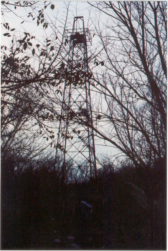
Last standing Oil Derrick (located on west side of Codell Ave in 34-11-16) This well was drilled in 1946 by the Texas Company on the AE Johansen property. The lease is now operated by the Vess Oil Company and the property is owned by Schmeid Ranch LLC.
Dickey Dam (located on Saline River 18-11-17) you would travel east on an oil lease road from the Saline River Road. This was built by the Dickey Oil Company so that they could get across the river to their wells without having to go the long way around.

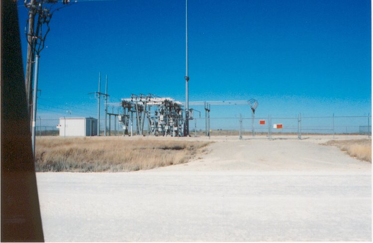
Hilltop Café (Power Sub station) located on top of the hill on the Saline River Road in 7-11-17. This was where everyone in the oilfield and several of the locals that lived in the area would go to eat. It is now a power sub-station.
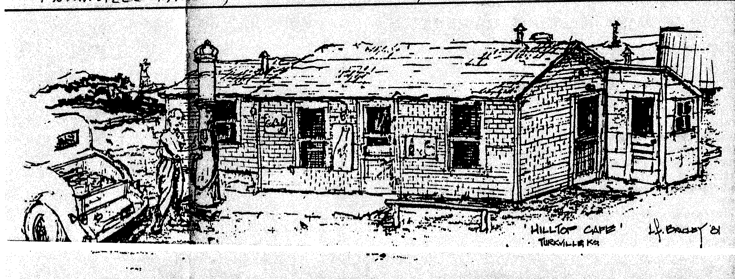
HillTop Cafe ' Turkville, Ks by LD Bradley '81 Sketch was in the Plainville Times, March 23, 1995 along with other pictures and the following article written by Margaret Houser.
The Hill Top Cafe, that is shown above came into being almost at the same time that the oil business took off along the Saline River Road and Valley. It was first opened about 1937 but the man from Hays who started by renting the location site and putting in the buildings didn't go ahead and open a cafe. As nearly as can be determined, Mr. and Mrs. Roy Curl had the cafe before World War II and sold it to Eunice Staggers. Floyd Fletcher's family moved to the river area in 1939 and his mother cooked in the cafe soon after that. Any old timers asked about the Hill Top Care immediately mention Eunice Staggers. Her husband, Walt, worked in the oil field and she operated the Hill Top Cafe, buying it in 1941. She sold it briefly in 1944, but she missed running it so much that she bought it back a few months later. Her daughter remembers that she owned it for about 12 years. When Walt retired in 1955 the Staggers moved to Salina. The Hill Top was never a fancy eating place. For part of the years of its existence it didn't have an indoor bathroom, but it was a place that all the men who worked in the area eagerly came to. Eunice's food was known for miles around. Her niece remembers serving 100 dinners on some days and for a cafe of this size and its remote location, which was 15 miles from town, this shows that the Hill Top had quite a reputation. On Sundays, people, families, would drive out from Hays to enjoy an excellent home-cooked meal. Eunice Staggers sold the Hill Top to Lula Ward, when she retired from restaurant work and then the ownership changed hands several times in the next few years. The Roy Curls had it again for a short time. A Mrs. Brown owned it before LeRoy and Elda Lovin bought it in 1962. By this time living quarters were included in the buildings at Hill Top and that was where the Lovins lived. When they decided to close, they disposed of the restaurant equipment--the oil activities in the area had quieted down and changed drastically from what it had been nearly 30 years before. All oil activities in this part of Kansas had changed. Nothing was done then in the frenzy of activity that it had been when oil was first discovered. Many of the residential settlements along the river called "Camps" were done away with. The houses were sold and moved off, but the memories now of the senior citizens who lived there and shared the exciting life of those days are another chapter in the history of Kansas. The drawing of the Hill Top Cafe was done by Lynn Dale Bradley of Hutchinson. His family lived in the area during the boom years and he was familiar with the cafe and the people who had it. The Lady in the picture standing outside of the front entrance was Mrs. Ruth Fletcher, the cook. The picture would be more than 50 years old. The picture with the cars was taken at the noon hour rush, showing the business the restaurant did each day. Roy Carmichael loaned the cafe picture by Bradley and contributed man of the facts used. Elda Lovin also helped as did many others who had lived in that area. The pictures of Mrs. Fletcher and the cafe, with cars, was furnished by Marie Goodpaster, a daughter of the Walter Staggers, who now lives in Russell.
(I remember eating at the Hill Top Cafe, when I was younger. Our family still has one of the counter's that was bought by us when the restaurant equipment was sold by the Lovin's)-Jackie
Riverside Inn (private property) located in the north end of 15-11-17 at the intersection of Saline River Road & Codell Ave. This was a bar & inn, that had disappeared by 1950. Some say that it was the local bordello. This property is now owned by D & S Farms.
First producing oil well in Ellis County Bemis-Shutts Field Shutts –1928 (need to add more information) Most of the wells first drilled in the Bemis pool were considered dry holes if they did not produce at least 50 barrels a day. The first producing well in Ellis County was drilled on the William and Bertha Shutts farm and the Fred and Mae Bemis Ranch in 1928. The Shutts and the Bemis well was two miles apart.
Oil City (located 2 miles south of Saline River Rd on Codell Ave) had 2 cafes, grocery store, lumberyard, a general store, welding shop, liquor store, honky-tonk & RC Williams Trucking, along with several portable wooden shacks. Maps show that it was located on the east side of Codell Ave, but split by the section line, with some on the north & some on the south; but word of mouth has it on both the east and west side of Codell Ave. Bessie Bullock talked of washing all the men’s greaser when she lived in the Baumer House, which was within walking distance south of Oil City. (nothing left of Oil City, the Baumer House is still standing today-2009)
Cactus City (located in 15-11-17 somewhat towards the middle) had 2 lumberyards & a café, believe to be near 1st producing oil well in Ellis Co (nothing left)
Hinesville (SE/4 9-11-17) Dan Hines kept his bulldozers & welding shop there (today that would place it at the corner of 310 th Ave & Saline River Rd) (nothing left)
Turkville (only school building left with basketball court-private property of Steve Creamer) see information under schools
Saline Valley (buildings and basketball court left-private property of Gary & Barb Anderson) see information under schools
First Baptist Church of Turkville (only concrete foundation marks its existence) see pictures & information under churches)
Horse Thief Canyon- A county road that winds its way through the hills for about 5 miles worth of canyons, where horse thieves had a cabin hidden in the hills, in which they hid out from the law. There used to be ruins, but most of the people who knew where they were located are deceased. If you drive through here during the spring, you would see the hills covered in wild flowers. These hills also have many caves in them, also a lot of rattlesnakes. Remember the box canyon is located on private property and you need permission. It is located below Devils Tower. The horse thieves would go to Nebraska, steal horses, bring them back, change the horses looks, then drive them to Colorado to sell. They would then steal more horses, bring them back, and then take to Nebraska to sell. We have three of the names, which two were local boys. Nothing is known about the thief called Johnson. Of the two locals: One's grandfather caught him stealing tobacco, the grandfather tied the boys hands behind his back and put him on a horse with a rope around the boys neck. It's told by the family that the grandfather said, "You can steal horses, but you can't steal my tobacco." The boys sister was in the haymow, and before their grandfather could hit the horse, the sister cut the rope with a large scythe. The boy took off on the horse, leaving the area, and was never heard from again by the family. The other local boy, was caught by a sheriff in Colorado and spent the rest of his life in jail in Carson City. He died in prison and was buried there. His family never mention him again and you can't find anything in writing about him, even though the rest of the family is written about in history, and the rest of the family is buried nearby in another county.
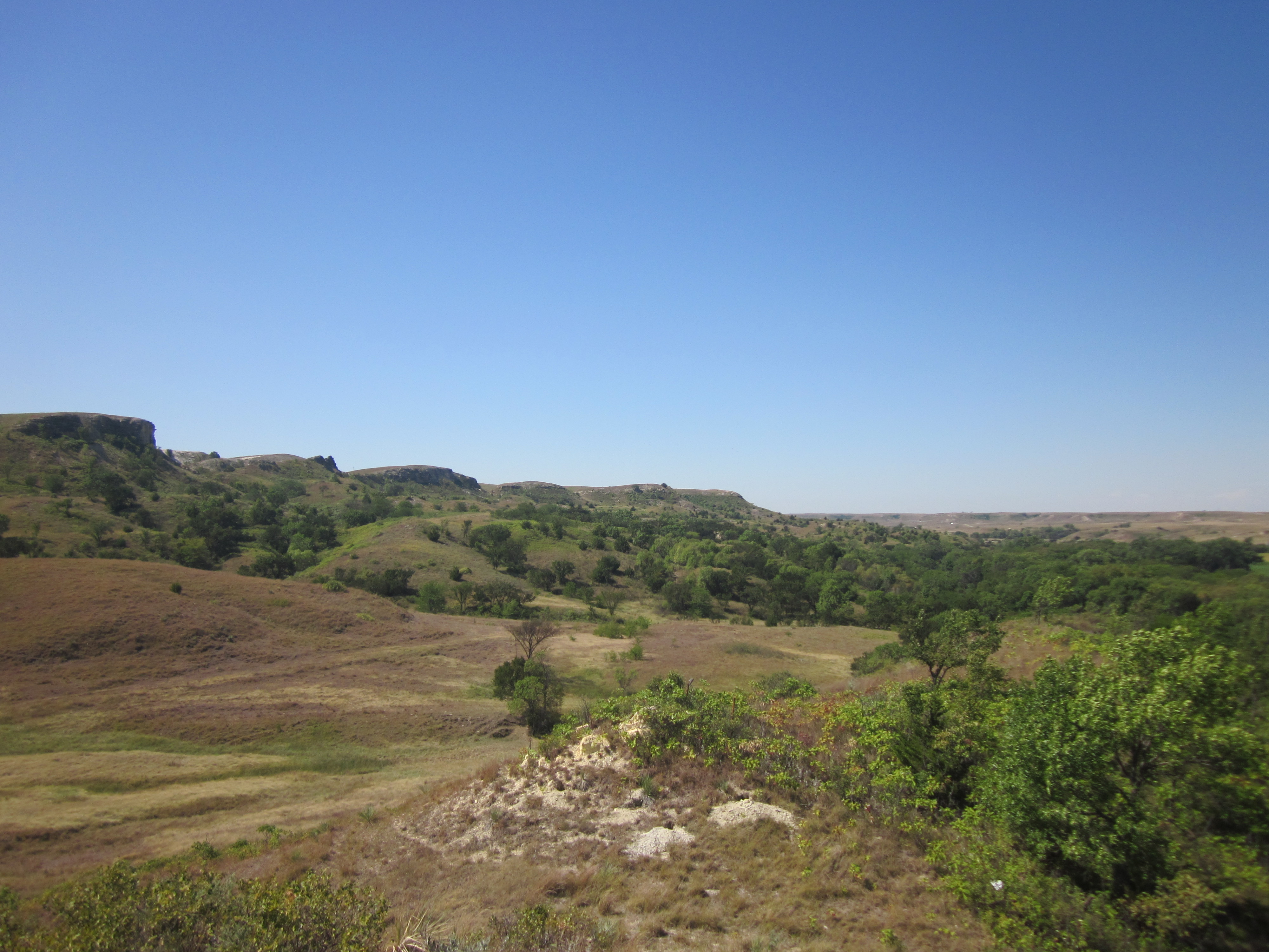
Looking upon Horse Thief Canyon Area -Note: Devils Tower

Devils Tower located above Horse Thief Canyon
Kaba Canyon – named for the family that lived in the Canyon, now known as Toulon Ave. dirt road that runs north starting at the Saline River Road.
Skull Hill located near the Margay/Sohio camp in the Bemis field
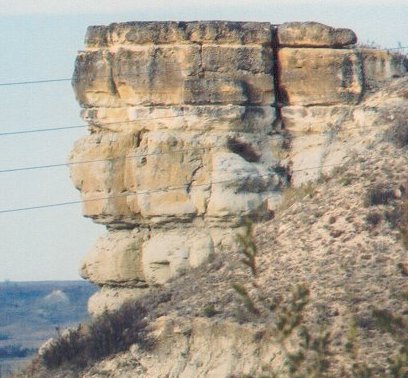
Up Close of Skull Hill November 2003
Dean Hill – located 21-11-18 & 28-11-18 (today part of Dean Hill Ave)
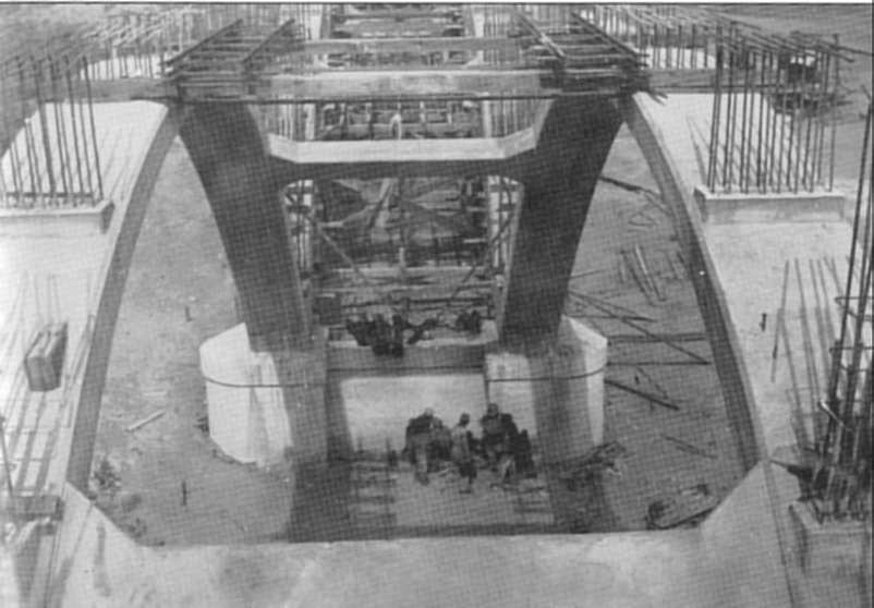
Was once part of Hwy 183, when the highway was a dirt road, sometimes people actually had to go in reverse to get up this hill. A new Saline River Bridge was built in 1930 to the east and the highway was blacktopped making it much easier to travel. Once again a new Saline River Bridge has been built 2009, just to the west side of the bridge that was built in 1930.
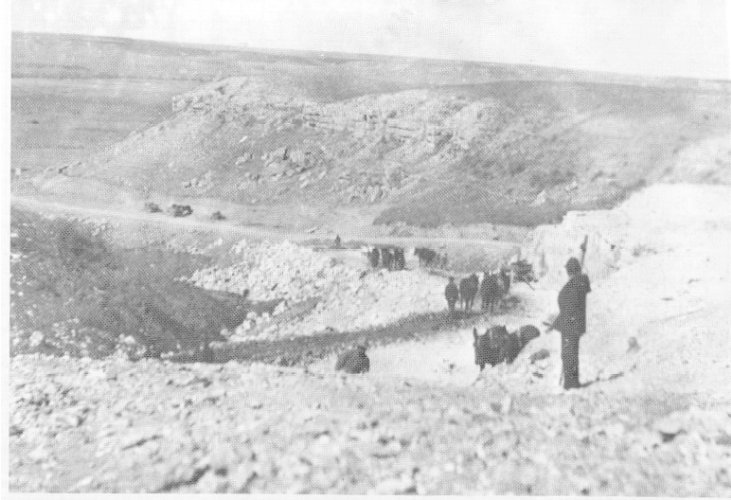
Building the road over Dean Hill by Felten Construction Co in 1920’s
(Photo property of ECHS)
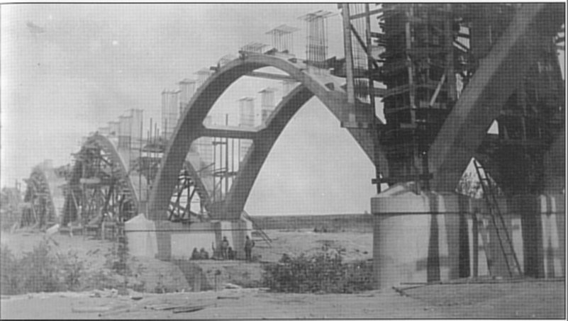
1930’s-Building Hwy 183 Bridge over the Saline River
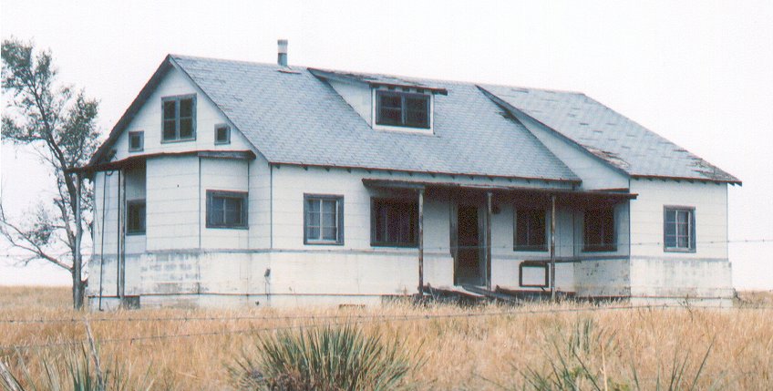
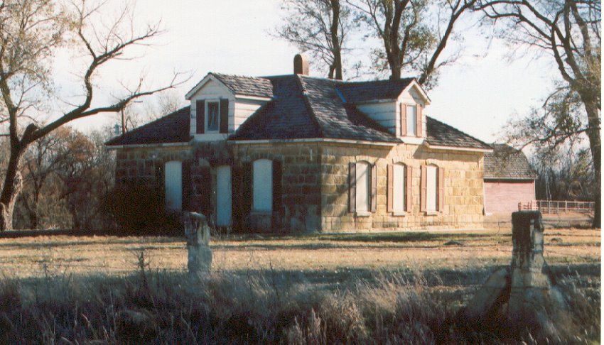
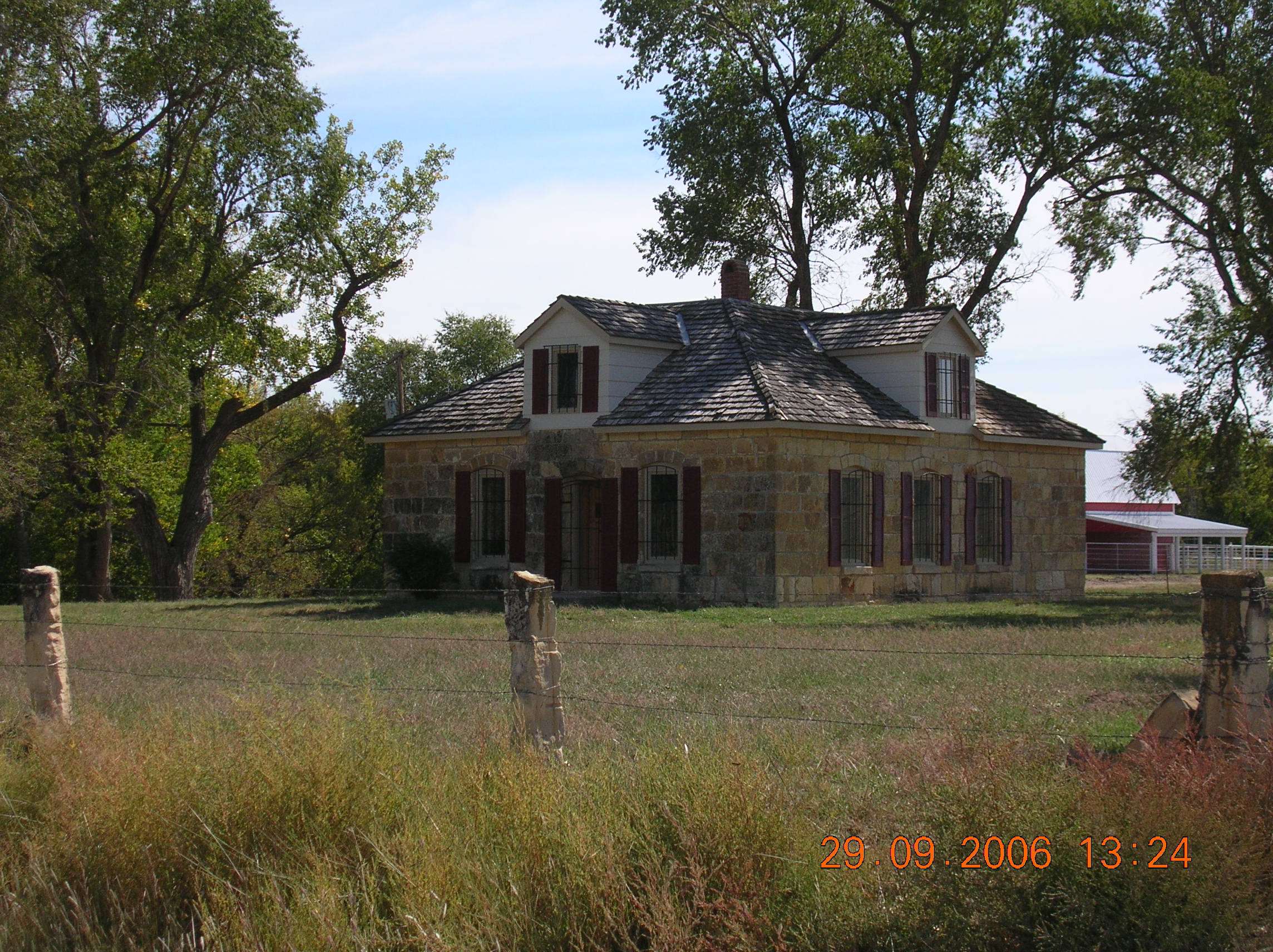
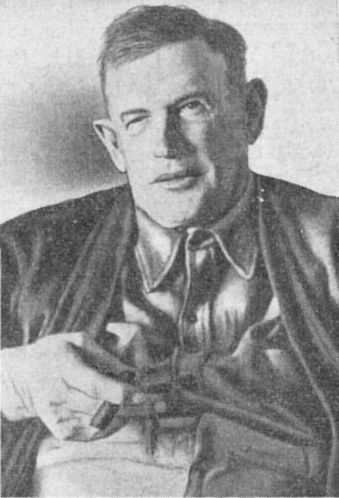
MP Cress House (1st house in area that had an elevator & dishwasher) located 18-12-17
Mel Cress was also a ham radio operator & kept his equipment in the attic
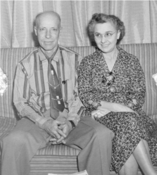
MP (Mel) & Margaret (Hunt) Cress 1957
Meier's Mill (located on the Saline River bend in the SE/4 of 7-11-17) Jacob Meier built the mill on the Saline River out of wood and stone, the stone was quarried from the hills just about 1 mile north of the sight of the mill. Vera Bollig Havalas Parke knew the exact location of the mill. Schmeidler's now own and maintain the property that the mill was located on.
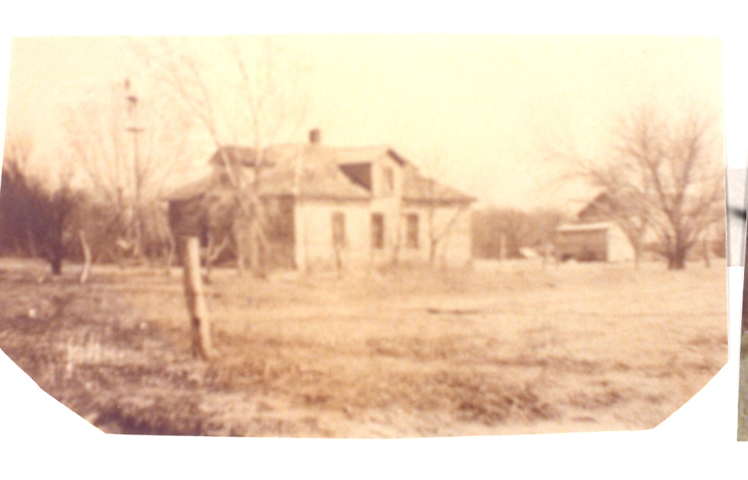
Meier’s/Bollig House This house was built by Andreas Meier, son of Jacob Meier. He built it out of the stones that were at Meier’s Mill. The house at one time housed the Bollig family, who are descendants of Jacob Meier. The first picture was loaned to me to copy and use by Vera Bollig Havalas Parke. The second photo shows how the house and barn were while Ross and Marianne Beach owned the property. The next two pictures following are what the house and barn looked like after Don Schumacher bought the place. Don has had much more done to the house inside and outside since I took the pictures.


Bill Bollig’s map – The Jacob Meier Homestead (1877) to my mother Elizabeth Meier Bollig in the year 1925, drawn by Bill Bollig in the year 1977, as he remember the farm age 5 in 1938. Dad, Mother, Andy, Gus, Bill & Hank Bollig moved onto the homestead in 1916. There were thirteen children in the Peter Bollig family, which were the grandchildren of Jacob Meier. The drawing has squares & Numbers on each square, No.1 to No. 26 and each No. has a history behind it. The history is written up in a book by Bill.
The following was submitted by Rosemary Larson, Jacob’s great-great-grandaughter, with help from William Bollig, Sterling Co, a great grandson to be placed in the Volume’s of “At Home In Ellis County, Kansas 1867-1992” I have only included the part pertaining to Jacob Meier being on the Saline River, the rest can be found in Volume 1 Page 124 & 125.
Meier’s Mills
Jacob Meier arrived in Ellis County with his family – a son, Andreas and his family – on 11-1-1876. Jacob was considered a wealthy man bring with him about $80,000 which he probably received from his brother, Andreas, as payment for his portion of the lumber and mercantile business in Katherinestadt, Russia.
Shortly after the Meiers’ arrival, Jacob intended to open a lumber yard in Hays City; but by 11-15-1876, Jacob and Andreas had purchased land, horses and cattle at North Fork (Catherinestadt). The following spring the sod was broken with a large number of teams of horses and plows to ready the rich soil for planting.
“The Russians are talking of building a mill at some point on the Saline,” said the Hays City Sentinel of 4-27-1877, “as they fear the supply of water in Big Creek is insufficient.”
By 4-2-1877 Jacob meier ad decided to build a water-powered, custom mill on the Saline River when he purchased the SW/4 8-11-17 from John Irwin. The Saline River flowed through this quarter of land in a U-shape making it most suitable to obtain a good supply of water for a grist mill.
Jacob immediately ordered lumber and al the materials necessary for a mill which arrived at the depot in hays City about the middle of June. These were taken to the mill site on the Saline 16 miles north of Hays City. The mill was estimated to cost about $10,000.
The stone used was quarried from the hills about one mile north of the mill site.
“Meyer’s [sic] mill is progressing rapidly,” reported the Senteniel on 10-12-1877, “and three run of stone will be in operation by the first of January. The mill is to be 28 x 48, three stories high, and of the best quality of stone. Meyer [sic] has purchasd first-class machinery and will run a first class mill.”
“The race for the turbine wheel is about completed and the dam proer will be commenced immediately. Six teams are hauling rock. The mill itself is finished above the basement, and millwrights are fitting in the timebers for shafts, stone, etc.”
The lower wall was over four feet thick and from foundation to comb of roof 56’ in height. The masonry cost $4,050; the milling machinery about $3,000.
The mill was completed in early December. With water being “admitted to the wheels, wheat turned into the hoppers, mill-stones will revolve and the first flour ever ground in Ellis County will run through the bolts.” Jacob Meier celebrated the completion of the mill by giving a dance.
In early January, 1878, the stone dam was completed; but at the end of January, 30’ of it was washed out. It was immediately repaired.
Cephas Grass, hired as the chief miller, prepared the burr stones ready for grinding and the Meier mill was ready for business.
Meier’s ad appeared in the Sentinel on 2-8-1878: “Important to Farmers. We hereby announce to the citizens of Western Kansas that our mill will be in running order by 19th of Feb, and we will be prepared to purchase wheat, rye, etc. at the highest market price; and do custom work. J.Meier & Son.”
On 2-18-1878 the first flour was turned out at the Meier’s Mill. The premium brand was called, “Pride of the Saline” and the best grade, “XXXX.” The sacks carried the following inscription: Ellis County Mills, Manufacturers of Choice Winter Wheat by Meier and Son.
On 7-20-1878 the dam was badly damaged by high water, but was repaired by early August. In June of 1879 the dame was again washed out and repaired. The mill continued to meet the needs of the community. In June of 1880 the water was low on the Saline so the Meier Mill could run only four hours out of 24.
Since the mill was remote and often difficult for customer to find, the enterprising Jacob Meier plowed a furrow from Hays City so the farmers could follow it to the mill.
A month later, in July, the dam was washed out again by high water. Meier was discouraged and decided not to rebuild the dam. He decided to have the mill fitted with steam power since the dam could not be counted on.
In October of 1880 Jacob Meier purchased lots in Hays City, with the intention of building a steam-powered grist mill there. While the mill was being built in Hays, Jacob had men constructing a new dam on the Saline, which was completed March 1882. An ad was placed in the Ellis County Star in December of 1881. Both mills continued to produce flour. The Hays City Sentinel reported on May 10, 1883 that the mill and farm on the Saline were for sale. In 1886 Jacob turned the mill on the Saline over to his son, Andreas, who quite operating it the following year. Andreas used the stone from the mill to build him a permanent home along the Saline. Flood water’s of the Saline gradually destroyed the dam, until it was mostly all gone by 1893.
Frank Hall Ranch (H-H Ranch, LLC) (26-11-17) East side of Codell Ave.
Only the outbuildings are left. Frank was a son of John Thomas Hall. His son, Harold and family lived here till 1972, when they moved to Hays. It is still owned by Harold Hall in 2009. This was part of the original Sweetwater Ranch which had 4,000 acres.
Paper Moon House (SW/4 7-11-17) North side of Saline River Rd.
Romine’s owned a 2 story 4 square home just east of what is called the Cress Bridge. This house was used in the scene of Addie Pray (Tatum O’Neil) arriving at her aunts home in the Movie, “Paper Moon”. D & S Farms purchased the property and destroyed the house during 2000-2002. All that is left is a few cedar trees.
Hadley Range Road Named for the Hadley Family, starts at the Saline River Rd and runs south through the hills, to the Homestead Road.
One family that oil helped was the Hadley's. Mark Hadley and his sisters Lillie & Dollie enjoyed a nice income for the oil that was produced on their ranch along the Saline River. The family made a gift of money totaling $279,200. to the First United Methodist Church of Hays, and in the mid-1930's, they became major contributors to the Hays Protestant Hospital. In 1942 they funded the construction for the hospital's first major expansion to the tune of a $66,000. addition. Hays Protestant Hospital was renamed to the Hadley Memorial Hospital, by the board of directors. Once again the Hadleys funded another building project in early 1949. When Mark Hadley's death occurred in October 1949, he left almost the entire Hadley estate to the Hadley Memorial Hospital.
The following story was in "The Kansas City Star, Kansas City, Sunday, March 25, 1945, Section C - A Church Shares In Rich Rewards of the Hadley's Faith In Kansas - by E.B. Garnett Hays, Kas., March 24—Kansas continues to reward its hardy pioneers. Among the settlers who came to this part of the state in 1888, to remain as steadfast citizens through all the vicissitudes unruly Nature hurled over the land during the subsequent four or five decades, are Mark Hadley and his sister, Miss Dollie Hadley. Now blessed with ever-increasing riches from their land, they are sharing some of their wealth with a church and a hospital in Hays. Burt their blessings were few and their worldly possessions scant when they first arrived in Kansas. Their father, Henry Hadley, a farmer and stock man, had died in Illinois, where the family lived on a 240-acre farm near the town of Gridley, forty miles east of Peoria. The widowed mother, with five growing children, two sons and three daughters, had faith that the Lord would provide. She was told of cheap land in Kansas and was advised to come to this state. The family moved first to Jewell County in North Central Kansas, then, a year or two later, established their home in a sodhouse on a 1,200 acre tract of grazing land in Northern Ellis County, about twenty miles from Hays. Except for some bottom land along the Saline River, the ground was too rough and barren for farming. Bluffs several hundred feet high and deep canyons producing chiefly rocks and sand made up part of the ranch. However, there were cattle on the neighboring ranches. The Hadley boys, inheriting a fondness for livestock, believed they could “make a go of it” in cattle raising. A Devout Mother’s Faith The first years were years of struggle. The grasshopper plague that destroyed all food crops was followed by droughts. And, in the winter, terrible blizzards cost many cattle-raisers large parts of their herds. The Hadley brothers, with canyons to shelter their livestock, were more fortunate. They stayed on. Their mother Mrs. Sarah Hadley helped them make the good fight and kept the faith. She was a devout Methodist and assured her family that the Lord would provide. Today there is no Methodist in all this part of Kansas who doesn’t know about Mark Hadley and his sister and the striking way in which they have undertaken to repay a debt to the Lord. It was announced last week that they had given $197,000 to complete the large First Methodist church of Hays –a structure begun twenty years ago and left unfinished when funds were not forthcoming. Pledges for the church had been made by its members in the more prosperous years of the late 1920s, but when depression years came those who had subscribed in good faith lacked money to fulfill their pledges. So the basement of the church –the new church that was to have been – was enclosed and roofed over to provide a place of worship for the congregation until it could raise necessary funds to finish the building. Finally somebody thought of Mark Hadley and his sister. Mark was not a member of the church, but Miss Dollie was. And everybody knew, he being a bachelor and she a spinster, and the pair having no chick nor child to support, they had an income they couldn’t possibly spend. Why, it was said, they had so much money they actually didn’t know what to do with it. Additional Funds for a Hospital Also, they knew Mark and his sister had contributed $45,000 out-right to the Hadley Memorial hospital for an addition in 1942 and always had said they would give more to that institution when needed. They were glad to support it as a tribute to the memory of their brother who died just about the time their land was beginning to make the Hadley’s rich. Moreover, last year Mark had told the church trustees he and Dollie would help them out some whenever they were ready to go ahead on the new sanctuary. And Miss Dollie had let it become known that she and Mark wanted to do something for the church in memory to their sister, Miss Lily Hadley, who died two years ago. As she was a spinster, too, her fortune was left to Mark and Dollie, now the only surviving members of the Hadley family and joint owners of the estate. The Hadleys’ fortune comes from oil leases. Their cattle ranch, now comprising 2, 720 acres, stretches between the rich Bemis and Burnett fields in Northern Ellis and Southern Rooks counties. This acreage (there are four sections, extending three and one-half miles from north to south, with a quarter-section adjoining on the west) overlaps both oil fields, although the entire ranch is in Ellis County. To find out just what individuals who had so much money they didn’t know what to do with it actually were doing with it, the writer drove over to the ranch from Hays one day this week to see Mr. Hadley and his sister. Before beginning the drive, we had heard that when they were little girls, many years ago, Dollie and her sisters had been caught in the rushing waters of a flash flood and had clung to the limbs of a tree while they prayed to God for rescue. Then, as the story went, their hearts were so filled with thankfulness for being saved that they promised they would spend their lives trying to express their gratitude by helping others in distress. It was such a beautiful story of faith, of mortals striving to repay a debt to the Great Protector, I wished that the late A.B. MacDonald could have lived to have written it as an Easter sermon. I imagined that “Mac” would have stressed the Rock of Ages theme and turned out another of his religion-tinged classics. Her Version of the Tragedy The truth is that dramatic as the episode was, the story appears to have been embellished considerably through the years of retelling. Miss Dollie told me that it happened so long ago – June 10, 1894 – that she had only dim recollections of the tragedy. “I was not there,”she said. “My mother and one of my sisters – Hattie – both lost their lives in the flood. It was my other sister, Lily, who clung to the branches of a tree and cried for help until rescuers came.” “You don’t know whether she prayed?” “I presume she did, for I believe anyone prays in time of distress. It was a Sunday morning and they were going to church. Attempting to cross the Saline River at a ford north of this ranch, they didn’t realize the water was so high, so drove into it. The wagon overturned in the water.” “Lily was an active church member, as far back as I remember. It is for her that we are making this contribution to finish the church at Hays. I, myself, don’t attend church as often as I should.” Mark Hadley said he was not a member of any church. Yes, he believed in churches and was glad to help all he could, but he felt that religion was a personal matter and the man who tried to behave himself as best he could might get along without being a church member. Past 60, Hadley is a tall, heavy set man. He is taciturn about his income and what he proposes to do with it. He impressed me as being as shrewd as a David Harum and as rugged as a Wallace Berry. “Oil and Cattle Don’t Mix” “I don’t get along any better or any worse since the oil strike,” he said. “Don’t think I’m any happier, anyway. Always have enjoyed life out here, and would have been just as happy still being a cattleman. I have no desire to be an oil man – and would have kept my cattle, but can’t get anybody to help now. At one time I was running about 400 or 500 cattle on this ranch, but had to sell most of them. Cattle and oil don’t mix none too well. The slush pools spoil the water holes – and the drilling they do on this ranch is not for water wells, you know.” “How many oil wells are producing on your ranch?” He though a moment and said: “Fifty-three.” As we drove around the ranch in a motor car, across prairie cattle trails, along new oiled roads made by oil company bulldozers, or up steep inclines from canyons to bluffs south of the Saline River, we could look to the north and east where a myriad of steel derricks stood forth against the blue backdrop of a cloudless spring day. The wells were thicker over there in the heart of the Bemis field, being put down 600 feet apart, Hadley explained. On his ranch, with leases paying royalties to single ownership, drilling was done with only one well to each 20-acre or 40-acre tract. The field was opened in 1935, with oil sand being hit at a depth of about 3,600 feet. The wells have potential production of from 300 to 600 barrels a day, but pumping is restricted owing to proration. Estimating His Income We wondered what the Hadley income might be if wells were drilled on his ranch as thickly as on the ranch of Fred Bemis, for whom the Bemis field was named. Mr. Bemis, with not much more acreage than the Hadley ranch, is said to have been offered 6 million dollars for his land soon after the oil strike of 1935. What his royalties bring him now, could not be learned, as it is believed he has disposed of some of his lease-rights. But Mark Hadley and his sister have retained all of theirs. A conservative estimate on the allowable production of the wells on their ranch indicates and income form royalties of more than $125,000 a year. And, of course, with lease contracts providing for the drilling of more wells in the future, their royalties would be increased greatly. Anyway, although in Hays they speak of Mark Hadley as the man nobody really knows, there is no thought that his liberal contribution to the church will leave him a poor man. And besides, he has given an additional $30,000 for a new wing to be added to the Hadley Memorial hospital here. Moreover, there is a hint or two about other gifts of the Hadleys to religious and charitable institutions. These contributions it is said have been made anonymously, in respect to the wishes of Mark Hadley and Miss Dollie. They are not inclined to talk about themselves, nor their benefactions. It was a struggle even to get Miss Hadley’s consent to being photographed. The portrait that accompanies this article was taken exclusively for The Star and is the only photograph she has had made since girlhood. The Hadley’s gift to the church is believed by Frank Motz, editor of the Hays Daily News, to be the largest amount of money ever given outright, at one time, for any religious, charitable or public cause in this city. Preciously the family had made generous contributions to pay the debt on the church property and for an electric organ in the basement where the congregation had been worshiping while awaiting for twenty years the completion of the sanctuary in keeping with the girls’ dormitory of the Wesley Foundation that adjoins it. Above the entire structure will rise a Gothic tower. The edifice will be of native limestone from quarries south of Hays. This building material is available now, so the Rev. William E Shuler, pastor of the church, believes work on the tower and sanctuary may begin within the next few months. When completed the building will have cost, including the dormitory and recreation center provided by the Wesley Foundation for young women students of the Kansas Sate college here, more than $350,000. The church auditorium will have seating capacity for 1,000 persons and will include a divided chancel, a handsome altar, a new pipe organ and stained glass windows. One large window, it is expected, will be for Miss Lily Hadley, who died in 1943, and in whose memory Dollie and Mark Hadley now are making their large gift in cash.
Pictures Included in the Article (Mark Hadley - March 1945, Dollie Hadley-March 1945, Hadley Ranch Home - March 1945, and the view of the Hadley Ranch - March 1945)
Hadley Ranch Area 2010
Page created by Jackie
Slimmer Langholz